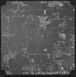
Photogrammetry
The ARDOT has high altitude black and white county coverage photography dating back to 1968. The photography scale is 1:20,000 (1”=1667’) for the years 1968 – 2006 and 1:24,000 (1“=2000’) for the years 2007 – current year. There is limited color coverage available from January 2003 – current year.
County photography is not flown on a specific schedule. Therefore, the year requested may not be the actual year available. Your order will be based on the year closest to the year you requested in that case. If color photography is available, your photo request will be printed in color. Please use our order form to request photos.

10 x 10 Contact Print |
10 x 10 Enlargement |
Color Contact Print |
 |
 |
 |
Pricing
(Effective January 1, 2018)
SIZE IS APPROXIMATE ON ENLARGEMENTS |
COST |
| 10"x 10" Contact Print |
$7.00 |
| 10"x 10" Enlargement/Paper |
$7.00 |
| 20"x 20" Enlargement/Paper |
$28.00 |
| 40"x 40" Enlargement/Paper |
$112.00 |
| 10"x 10" Contact Digital File on DVD |
$7.00 |
Prices for the above listed reproductions are revised annually and are subject to change without notice.
If an order falls between the sizes listed, you will be charged for the next larger size.
(Supersedes previous price list December 2017.)
Download GIS datasets and Free Aerial Photography from Geostor.